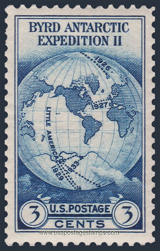
US 1933 Byrd Antartic Expedition 'World Map' 3c. Scott. 733

Series: Byrd Antarctic Issue
Stamp details: Byrd Antartic Expedition - World Map on van der Grinten Projection
Issued date: 09-10-1933 (dd/mm/yyyy)
Face value: 3c.
Emission: Commemorative
Watermark: No Watermark
Catalogue No:-
Scott (USA): 733
Stanley Gibbons (UK): 732
Michel (Germany): 359A
Yvert et Tellier (France): 323
Dimensions (height x width):
40mm x 25mm
Printer: Bureau of Engraving and Printing
Stamp Colors: Dark blue
Perforation: Perf 11
Themes: Map, Globe, Explorers
Total print: 5,735,940 (estimate)
Description:- The van der Grinten projection is a compromise map projection, which means that it is neither equal-area nor conformal. Unlike perspective projections, the van der Grinten projection is an arbitrary geometric construction on the plane. Van der Grinten projects the entire Earth into a circle. It largely preserves the familiar shapes of the Mercator projection while modestly reducing Mercator's distortion. Polar regions are subject to extreme distortion. Lines of longitude converge to points at the poles.
Source: en.wikipedia.org/wiki/Van_der_Grinten_projection
Source: en.wikipedia.org/wiki/Van_der_Grinten_projection
* Philatelic Auction Houses
* Philatelic Books
* Philatelic Federation
* Philatelic Libraries
* Philatelic Magazines
* Philatelic Society
* Stamp Dealers Association
* Stamps Exhibitions
* US Post Offices
* Worldwide Philatelic Bureau