US 1956 Devils Tower, Northeastern Wyoming 3c. Scott. 1084
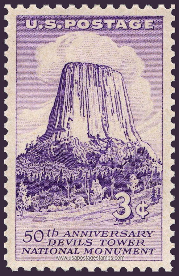
Series: Devils Tower Issue
Stamp details: Devils Tower, 50th Anniversary
Issued date: 24-09-1956 (dd/mm/yyyy)
Face value: 3c.
Emission: Commemorative
Watermark: No Watermark
Catalogue No:-
Scott (USA): 1084
Stanley Gibbons (UK): 1086
Michel (Germany): 706
Yvert et Tellier (France): 621
Dimensions (height x width):
40mm x 26mm
Printer: Bureau of Engraving and Printing
Print Method: Rotary press
Stamp Colors: Violet
Perforation: Perf 10½ x 11
Themes: Monument, Mountains, Landscape
Total print: 118,180,000 (estimate)
Description:- Devils Tower (also known as Bear Lodge Butte) is a butte, possibly laccolithic, composed of igneous rock in the Bear Lodge Ranger District of the Black Hills, near Hulett and Sundance in Crook County, northeastern Wyoming, above the Belle Fourche River. It rises 1,267 feet (386 m) above the Belle Fourche River, standing 867 feet (265 m) from summit to base. The summit is 5,112 feet (1,559 m) above sea level.
Devils Tower was the first United States national monument, established on September 24, 1906 by President Theodore Roosevelt. The monument's boundary encloses an area of 1,347 acres (545 ha).
Source: en.wikipedia.org/wiki/Devils_Tower
Devils Tower was the first United States national monument, established on September 24, 1906 by President Theodore Roosevelt. The monument's boundary encloses an area of 1,347 acres (545 ha).
Source: en.wikipedia.org/wiki/Devils_Tower
* Philatelic Auction Houses
* Philatelic Books
* Philatelic Federation
* Philatelic Libraries
* Philatelic Magazines
* Philatelic Society
* Stamp Dealers Association
* Stamps Exhibitions
* US Post Offices
* Worldwide Philatelic Bureau