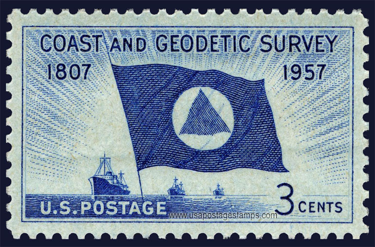
US 1957 Coast and Geodetic Survey 3c. Scott. 1088

Series: Coast and Geodetic Survey Issue
Stamp details: Flag of Coast and Geodetic Survey and Ships at Sea
Issued date: 11-02-1957 (dd/mm/yyyy)
Face value: 3c.
Emission: Commemorative
Watermark: No Watermark
Catalogue No:-
Scott (USA): 1088
Stanley Gibbons (UK): 1090
Michel (Germany): 710
Yvert et Tellier (France): 625
Dimensions (height x width):
25mm x 40mm
Printer: Bureau of Engraving and Printing
Print Method: Rotary press
Stamp Colors: Dark blue
Perforation: Perf 11 x 10½
Themes: Flag, Ships, Transports
Total print: 115,235,000 (estimate)
Description:- The National Geodetic Survey (NGS), formerly the United States Survey of the Coast (1807–1836), United States Coast Survey (1836–1878), and United States Coast and Geodetic Survey (USC&GS) (1878–1970), is a United States federal agency that defines and manages a national coordinate system, providing the foundation for transportation and communication; mapping and charting; and a large number of applications of science and engineering. Since its foundation in its present form in 1970, it has been part of the National Oceanic and Atmospheric Administration (NOAA), of the United States Department of Commerce.
Source: en.wikipedia.org/wiki/U.S._National_Geodetic_Survey
Source: en.wikipedia.org/wiki/U.S._National_Geodetic_Survey
* Philatelic Auction Houses
* Philatelic Books
* Philatelic Federation
* Philatelic Libraries
* Philatelic Magazines
* Philatelic Society
* Stamp Dealers Association
* Stamps Exhibitions
* US Post Offices
* Worldwide Philatelic Bureau